
Panorama Trail
Yosemite National Park, California

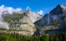
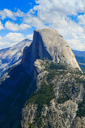
Yosemite National Park is a veritable treasure trove of scenic wonders—Half Dome, El Capitan, Bridalveil Falls, Yosemite Falls, and the entire Yosemite Valley delight travelers from near and far on a regular basis.
Visiting this incredible national park never gets tiring—even after exploring the park on six different occassions, we have found that there is always something left to discover. So in August of 2013, we set out to do just that—with the Panorama Trail being the focus of our visit.
 |
 |
 |
 |
 |
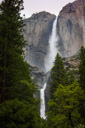
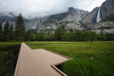
Upon arrival, we checked into our accommodations at Yosemite Lodge, and then set off to explore the park—our first stop, Yosemite Falls! On this and previous visits to the park, (during May, June, July, and August of prior years), Yosemite Falls was mostly nonexistent (except for May of 2008)—Yosemite Falls is dependent upon snowmelt for water volume, and is therefore seasonal, making the best viewing time May or early June.
 |
 |
 |
 |
 |
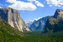
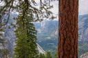
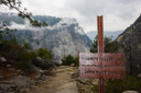
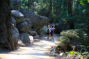
After exploring the park by car, we decided it was time to hit the trail—the Panorama Trail to be exact, this 8.5 mile trek encompasses both Glacier Point and the Mist Trail, with spectacular views everywhere in between. Including Panorama Point, Illilouette Falls, and the eastern Yosemite Valley.
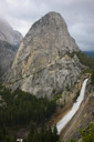
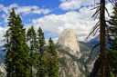
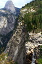
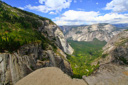
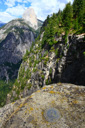
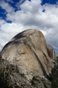
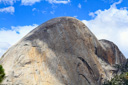
On its way to the valley, the trail crosses Illilouette Creek at the top of Illilouette Fall, skirts the top of the Panorama Cliffs, granting the hiker an amazing view from Panorama Point of Liberty Cap and Nevada Fall launching itself over the cliff into Yosemite Valley—five famous waterfalls for the price of one.
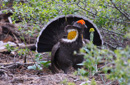
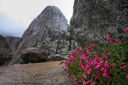
Leaving Glacier Point, we followed the Panorama Trail as it switchbacks downward through an old burn—chinquapin, Manzanita, and ceanothus line the trail, and bright red snow plants peak through the ground cover in spring. Another possible highlight of a spring or early summer hike is the chance to spot, or at least hear, a sooty grouse (previously known as a blue grouse)—these birds, the size of a small chicken, have a call similar to the sound produced by blowing over the mouth of a bottle and the males display bright yellow throat air sacs when courting females. Much to our surprise, we crossed paths with a pair almost immediately after beginning our hike—the chance to see the beautiful display of the male was truly a National Geographic moment.
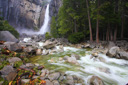
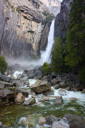
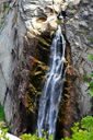
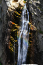
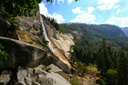
Continuing our descent into the Illilouette Gorge, we could soon hear the waters of Illilouette Creek—just a little further down the trail, and we came to the slightly obstructed view of Illilouette Fall, tucked back into a notch in the gorge(follow the spur trail for better views). Next stop, the 2.1-mile mark and the Illilouette footbridge—at this point, we explored the creek and the snow plants growing near the water before starting the climb out of the gorge.
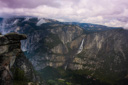
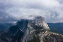
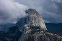
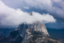
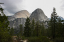
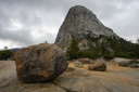
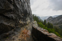
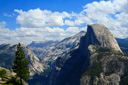
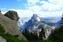
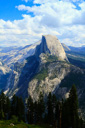
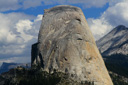
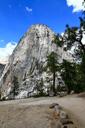
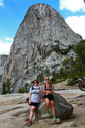
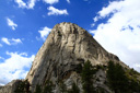
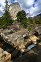
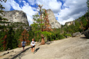
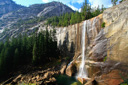
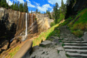
From the bridge, the trail climbs rather steeply up and out of the Illilouette Gorge until it reaches the top of the Panorama Cliffs—as you hike along the ridge look for an unmarked trail leading off to the left, this path takes you to Panorama Point. From this vantage point, you get spectacular views of Yosemite Valley, and Half Dome—an even better vista waits down the trail, where Liberty Cap and 584-foot Nevada Fall finally come into view. We even had a visit from a Stellar Jay while we rested and enjoyed the view. Eventually, the Panorama Trail leaves the ridge and switchbacks down to the valley past babbling brooks and mossy rocks—a slippery endeavor when it is raining and/or sleeting..
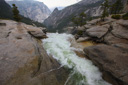
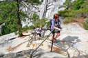
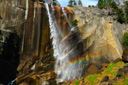
At the 5.0-mile mark, the Panorama Trail intersects with the John Muir Trail, but before descending to the valley floor, be sure to follow the signs to the right to the top of Nevada Fall—and be sure to stay behind the railings and away from the water’s edge, the river has claimed many lives here.
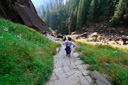
The remainder of the hike along the John Muir Trail is largely viewless—the exception is the beginning of the descent with its views of Nevada Fall, Liberty Cap, Half Dome, and Mt. Broderick. Once you enter the forest, the trek becomes a bit of a trudge-fest—especially in the rain, but the trail is well-graded and relatively easy on the knees.
The final vista point along the descent is at the Vernal Fall Bridge, where you can watch the powerful water crashing over boulders the size of minivans as it makes its way to the valley, now just a mile away. When you reach the end of the John Muir Trail, take a left and cross the bridge over the river where you will find the Happy Isles Shuttle Stop—jump on the shuttle, and enjoy the ride back to Curry Village or any other eastern Yosemite Valley destination.
May 2008 Gallery
 |
 |
 |
 |
 |
 |
 |
 |
 |
 |
 |
 |
 |
 |
 |
 |
 |
 |
 |
 |
 |
 |
 |
 |
 |
August 2013 Gallery
 |
 |
 |
 |
 |
 |
 |
 |
 |
 |
 |
 |
 |
 |
 |
 |
 |
 |
 |
 |
 |
 |
 |
 |
 |
 |
 |
 |
 |
 |
 |
 |
 |
 |
 |
 |
 |
 |
 |
 |
 |
 |
 |
 |
 |
 |
 |
 |
 |
 |
 |
 |
 |
 |
 |
 |
 |
 |
 |
 |