Red Dot Trail - Mt Tammany
Delaware Water Gap NRA, New Jersey
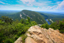
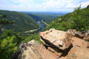
Mount Tammany, a sought after summit in the state of New Jersey, sits perched 1,526 feet above the Delaware River – located within the Delaware Water Gap National Recreation Area, an area set aside to preserve the landscape produced when the Delaware River carved a notch through the Kittatinny Ridge (a water gap), the peak is ubiquitously listed as one of the best hikes in New Jersey.
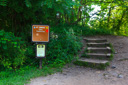
The Red Dot Trail, the shortest route to the summit, is officially located in the Dunnfield Creek Natural Area – the trailhead can be accessed by parking at either the Dunnfield lot on the north side of I80, or at the Kittatinny Visitor Center on the south side. If you park at the Kittatinny Visitor Center, your only choice if traveling in an RV, you will have to walk across the road via an underpass to reach the trailhead.
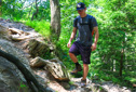
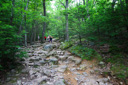
Once you locate the Red Dot Trail, found close to the entrance of the Dunnfield Creek Parking Area, make your way up the wooden staircase and then keep left to follow the red blazes – the trail climbs 1,250 feet in 1.5 miles along the western slope, reaching the summit of Mount Tammany along a steep, strenuous, albeit short, rocky path. .
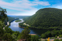
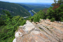
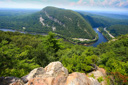
After climbing about 400 feet, you reach the half-mile point and a bluff with a fantastic view of “The Gap” – Mount Tammany in New Jersey, Mount Minsi in Pennsylvania and the Delaware River in between make for a dramatic vista.
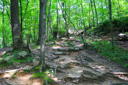
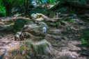
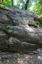
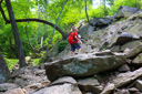
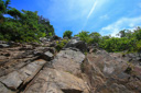
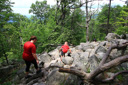
Continue climbing along the Red Dot Trail to reach the highpoint summit – the trail becomes extremely rocky and steep past the first viewpoint, so take your time and watch your footing.
At the 1.5 mile mark you will find yourself standing on the top of Mount Tammany – the rocky summit affords broad views of the Delaware Water Gap. Scramble down the rocks for even more expansive views and to catch a glimpse of raptors floating on the thermals – pick a boulder of your own and enjoy a well-deserved rest break.
From the summit, you can retrace your steps by returning on the Red Dot Trail or you can continue down the other side of the mountain along the Blue Trail – the Blue Trail, while not as steep, is a half-mile longer. We opted to return via the Red Dot Trail for a roundtrip hike of 3 miles.
 |
 |
 |
 |
 |
 |
 |
 |
 |
 |
 |
 |
 |
 |
 |
 |