Appalachian Trail to McAfee Knob – McAfee Knob Area, Virginia
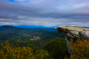
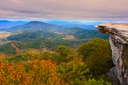
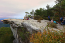
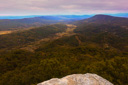
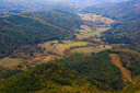
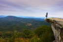
McAfee Knob, a rock protrusion resembling a diving board, juts out from the side of Catawba Mountain high above Virginia’s Blue Ridge Mountains - from the rocky perch you are afforded incredible views of the Catawba and Roanoke Valleys and the chance to savor one of the finest views along the Appalachian Trail.
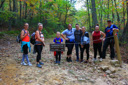
Day hikers set on reaching McAfee Knob will begin their adventure at the parking lot along VA 311 - you will have to cross the road to reach the 3.9 mile section of the Appalachian Trail (AT) that leads to the lofty summit.
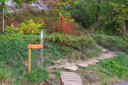
After hiking approximately 0.3-mile from the road, you will come to an informative kiosk - from here, you can continue along the AT or choose to hike the Fire Road to McAfee Knob.
The paths are equidistant, but the AT is rated moderately strenuous and the Fire Road easy - we recommend taking the AT up, for a challenging hike with rewarding views, and the Fire Road down, for a less strenuous, easier on the knees, descent.
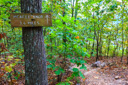
If you choose to follow in our footsteps, bear right at the kiosk and follow the white blazes along the Appalachian Trail - you’ll be standing on McAfee Knob in 3.6 miles.
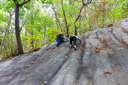
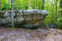
The route to the top gains 1,407 feet (most of it in the last 1.5 miles), as it passes through 400+ million years old Silurian sandstone known as the Tuscarora Formation - adventurous hikers will delight in the opportunity to climb the steep rock slabs and slowly eroding sandstone blocks.
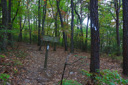
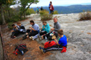
As you make your way to the summit, watch for two classic shelters located along the historic Appalachian Trail - you will pass both the John Springs Shelter and the Catawba Spring Shelter, great places to take a rest stop and possibly meet a thru hiker.
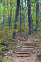
Continue climbing along the AT and you will eventually cross the Fire Road once again - from this point, the knob is approximately 1.4 miles away. From the intersection, climb the stone steps to continue along the AT towards the knob - watch for a small sign that says “overlook 1.3 miles”, follow this route to the summit.
After a bit more climbing you will reach a clearing/power line right of way, you are now 0.3 miles away from your first view of the valley - watch for an opening in the pine forest covered ridge that reveals the sprawling vista of the Catawba Valley.
From the viewpoint, it’s another 0.5 miles to McAfee Knob - along this section you will hike alongside massive boulders in an area known as the Devil’s Kitchen.
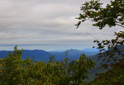
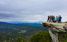
In no time, you will find yourself standing on McAfee Knob - the 270-degree view from this point is one of the finest views along the Appalachian Trail, and it is hailed as one of the Natural Wonders of Virginia’s Blue Ridge Mountains.
Rolling wooded peaks and pastoral valleys stretch into the distance as far as the eye can see - take your turn posing on the iconic rock and then soak in the views of the striking landscape, which on a clear day includes the town of Roanoke, North Mountain, and the Tinker Cliffs.
 |
 |
 |
 |
 |
 |
 |
 |
 |
 |
 |
 |
 |
 |
 |
 |
 |
 |
 |
 |