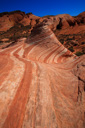
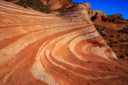
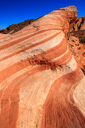
Fire Wave
Valley of Fire State Park, Nevada
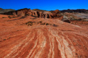
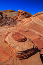
Fire Wave, an undulating swirl of fiery hued sandstone, has eluded many hikers who venture from the lights of Las Vegas, and others, to the solitude of the Valley of Fire—but now, the park’s rangers have opted to share its location, delighting visitors that crave a fantastical desert fix.
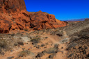
Valley of Fire State Park, located 55 miles northeast of Las Vegas, derives its name from the abundant red sandstone formations found in the 42,000 acre protected area—sandstone beehives, arches, petrified logs, elephant rock, and the fire wave make this park a must see for anyone who finds themselves in Nevada.
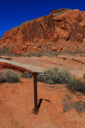
Locating the trailhead for Fire Wave is simple, from the Visitor Center, head north on Mouse’s Tank Road—at the roughly 4.4 mile marker watch for a parking area(labeled P3 on the park brochure) on the left (west)side of the road. The trail leading to Fire Wave is located across the road from the parking area, on the east side of Mouse’s Tank Road—follow the footpath through the sand, past a green sign about the formation, descending toward a small sandstone bluff.
The trail skirts the edge of the bluff before emerging onto slickrock—cairns and reflector posts dot the landscape, leading the hiker in the right direction. After hiking a mere 0.6-mile, the wave formation comes into view—red, orange, yellow, and buff colored sandstone twist together like pulled taffy, undulating in, out, and above a small bowl-like structure. It is without doubt a beautiful and unique landscape, one that deserves respect and protection—tread lightly and leave no trace.
 |
 |
 |
 |
 |
 |
 |
 |
 |
 |
 |
 |
 |
 |
 |
 |
 |
 |
 |
 |