The Wave
Coyote Buttes North, Arizona
Hidden in the desolate area known as the Paria Canyon-Vermillion Cliffs Wilderness area near the Utah/Arizona border, you will find one of the most spectacular rock formations in the entire southwest—“The Wave”. This remarkable sculptured sandstone sits in the shadow of the Coyote Buttes and is reached, not by trail, but by navigation using landmarks or GPS coordinates. A permit is required to hike to this natural wonder, and only a lucky few are privileged enough to possess one on any given day. The Bureau of Land Management issues just 10 advance permits and 10 walk-in permits—so if it is solitude you are looking for, you will find it at Coyote Buttes. Luckily, we were able to obtain an advance permit over the internet on October 1st of 2001 for a cost of $5.00 per person—the date of our permit read April 30th, 2002 and we could hardly wait to start hiking.
When April 30th finally rolled around, we made our way to the Wire Pass Trailhead, arriving at 10:38am under beautiful blue skies—the perfect conditions for photography and hiking. As noted before, getting to “The Wave” requires some navigation skills, but it is relatively easy to find with a few tips. First, you must find the Wire Pass Trailhead—located off House Rock Road, which is an unmarked dirt road off Highway 89. You will find the turnoff between mile markers 25 and 26 of Highway 89—on the left, just past a bridge if you are coming from Page, Arizona. About 8 miles down House Rock Road, on the right side, you will come to the parking area for the trailhead—the Wire Pass Trail starts on the left side of the road. Park your car and be sure to display the parking pass that came with your permit, cross the road and head for the register box—after signing in, the adventure begins.
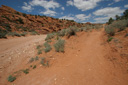
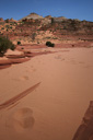
The hike from Wire Pass follows a wash for just a short while before veering right up an old rocky road—you will see a sign for Buckskin Gulch just past this intersection. We started climbing up the hill via this abandoned road until we came upon another register box—from there, the trail is very sandy and makes hiking a bit tedious, especially when you already have blisters from a previous hike!
Despite the sandy trail, we found hiking to our destination pretty straight forward, especially since we had obtained the GPS coordinates for “The Wave” prior to setting out on the trail—we highly suggest using one of these devices if you want to tackle this hike. We checked the GPS to make sure we were on track and then we headed for a deeply grooved red rock butte—at this point, you will notice a gully that leads to the top of the butte—climb this to begin the next section of the hike. Next, you will arrive at a saddle—from the saddle you want to stay parallel to the ridge without losing any elevation—a ranger at the information center told us that most people make a mistake at this point by climbing down the ridge. Staying at the higher elevation makes the hike much easier, and allows you to see your next landmark, the twin cones, from a better vantage point.
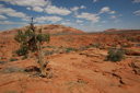
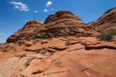
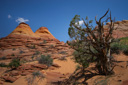
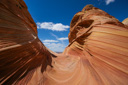
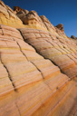
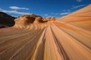
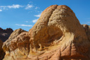
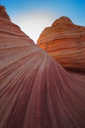
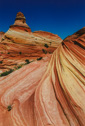
Keeping as high on the ridge as possible you now head for the twin cones—a geological wonder in their own right. The yellows, reds, and browns of the sandstone formations spiral up and down the entire length of the cones—making them look like giant swirled lollipops. In fact, the rest of the hike from the twin cones on is just one amazing view after another—all around you are these intense rock formations, most with these deep striations running horizontally across their surface. It becomes quite evident that you are getting closer to “The Wave”—even the rock underfoot has incredible patterns and colors!
As you make your way closer to the twin cones, bear to the left of the formation—from the left side of the cones, you should be able to see your next landmark. The landmark you are searching for is known as the black crack—a crevice that runs vertically down the buttes—below this crack you will find the area where “The Wave” is located.
As we headed for the “black crack” we could hardly contain our excitement—we were about to see one of the world’s most fascinating and beautiful places—would it be as stunning in person as it was in photographs?
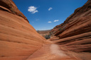
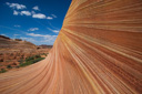
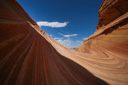
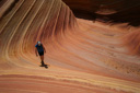
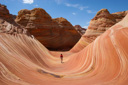
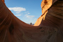
The “trail”, soon after leaving the twin cones, was now mostly flat and consisted of rock as far as you could see—the black crack still loomed in the distance beckoning us forward. It took us about thirty minutes to cross the bare rock where we then crossed what appeared to be another wash—great, more sand hiking—just what my sore feet needed. Thankfully, the sand section was short, and my blisters were numb anyway. Once across the wash, it was necessary to climb up the base of the butte—again, there is a gully that you can stay in to help make the hiking easier. As you near the top of the rock, it will start to level out and you will finally see “The Wave”—I immediately put my camera to my eye to capture forever what I was seeing. At that moment a gust of wind flew through “The Wave” bringing with it millions of tiny grains of sand—I spun around in time to protect my camera, not to mention my face, as we were sandblasted for a few seconds. The power of erosion was still at work on this piece of geology and I think it wanted us to know just that.
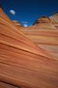
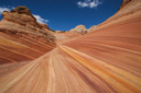
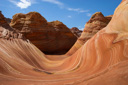
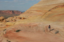
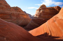
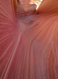
Tucked away within the maze of cliffs, canyons, and buttes is a destination unlike any other on the Colorado Plateau. Here, in the area called simply “The Wave” of Coyote Buttes, there exists a psychedelic microcosm of sensuously sculpted sandstone worn smooth by wind, water, and time. The intricate layers in the rock are composed of giant dunes deposited approximately 150 million years ago during the Jurassic period. As you hike along the sandstone highway in this fantastical place, imagine that this was once a vast Sahara-like desert along the west coast of North America.
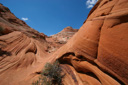
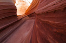
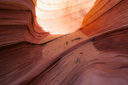
It had taken two hours to reach our goal—not nearly as long as one might expect—and we intended to spend several more hours exploring this wonder of the desert southwest. We climbed further and deeper into “The Wave” and every corner opened up a new and psychedelic view—the swirling patterns in the sandstone lead the eye on a phenomenal journey through time. It is immediately evident how this area got its name, as the rock literally appears to be flowing like water—it was absolutely spectacular!
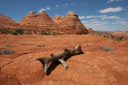
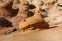
In addition to The Wave itself, several other beautiful icons can be found tucked away in this desert—among them, Hamburger, or Burger Rock, Brain Rocks, and The Second Wave. If, like us, you set out to find these formations, this is what you need to do to easily get there. First, once you find “The Wave” don’t climb up to the highest point on the eastern horizon, instead, make your way to the top of “the bowl” of The Wave—then head in a south to southwest direction until you see the hummocky known as Hamburger Rock. This bright yellowish orange rock formation stands about four feet high and totally looks like a hamburger when viewed from the south side, once you find this rock you are very close to the Second Wave, just keep hiking south. The Second Wave consists of long sweeping parallel lines that curve one way and then another. If you can time your arrival to near sunset, the last rays of the sun will turn this area a warm glowing red, just remember to allow enough time to navigate your back out of Coyote Buttes, you don’t want to get caught out here at night!
We spent several hours exploring and taking photographs before we decided it was time to head back. A place of this beauty is hard to describe in words, but I hope my photos allow you to share in this unique formation. The hike back was relatively easy and we arrived back at our car at about 4:00pm—another amazing hike was behind us, but the image of its beauty will be in our memory forever.
Gallery contains 105 Images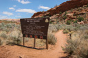 |
 |
 |
 |
 |
 |
 |
 |
 |
 |
 |
 |
 |
 |
 |
 |
 |
 |
 |
 |
 |
 |
 |
 |
 |
 |
 |
 |
 |
 |
GPS Coordinates for The Wave: Waypoint N3659.764 W11200.365